Wednesday, 28 October 2009

Stonehouse - The beginnings of a Postcard

After creating the Union Street panorama collage shown in one of the posts below, I decided to develop it further.  Firstly I thought about the way in which the two sides of the road are quite different to each other as described previously.  I therefore decided to try and represent this spearation somehow.  The following is the first of the images I created to try and show this:

The overlay over the top of the image is the outline of the road map of Union Street and the surrounding area.  I thought this would be a good element to add as it demonstrates the areas beyond the image as well as what can already be seen. By doing this it occurred to me that the image I produced looked as if the bottom images were reflections in the top as if Union Street is actually a river reflecting its surounding environment. This kind of overlay however could also be read as some kind of fog or mist over the road or area.  To begin with I felt I should follow the reflective route of this image and so continued to develop the collage to look more like a river reflection.  This is shown below:

In this image the line of the road is better formed to follow the image, better highlighting the road running through the image.  Although this image is better than the previous image, it also looks more like a cloudy substance which links back to the fog idea mentioned earlier.  This links with the pollution possibility for the Stonehouse future postcard and so this could well be developed as part of this.
Whilst thinking about reflections and the structure of the images I have created it occurred to me that as well as looking reflective, the greyed out areas also look like shadows of the images above.  This made me realise that the future always holds 'shadows' of the past. For example there are often old walls left where new buildings have been built to provide 'character' or because it did not make sense to remove it.  This wall however may have been there for hundreds of years and so has a lot of history in conflict with the area around it.  This also applies to many other structures such as paving and protected buildings, as well as history being retained in the ground itself.  I find this a very interesting concept that actually in 100 years time, it may still be possible to see some parts of the current Stonehouse still hidden amongst a newly regenerated Stonehouse.

Stonehouse - 100 Years in the Future

The next task in Transforming Stonehouse is to create a postcard for the area resembling what the area would be like in 100 years time, or at least some time in the future. In order to be able to do this I felt I had to consider the possible ways in which an area changes over a long period of time, and in particular the possible dramatic changes that occur in the next 100 years linked to possibilities of global warming and other current issues.  The following is a list of these possibilities:
  • Flooding - rising sea level
  • Drought - both hot(arid) or cold(ice) possibilities
  • Technological dependance - The world becomes completely digital
  • Loss of light
  • Loss of air
  • Atmospherical pollution - smog, no oxygen, clouded cities, leads to loss of vision
  • Radioactivity - wars or attempt at alternative energy
  • Too much waste
  • Ecofriendly civilisation - everything becomes 'green' e.g. travel, energy etc
  • Technological advancement - scifi elements e.g. defying gravity, ALife, technology becomes organic
Being that the annotations my group made of the area are based on views, light, green/organic, and traffic the concept for the future should be based on a development of one or some of these, but possibly also on the development of better technologies as this is likely to be inevitable.

Friday, 23 October 2009

Stonehouse - boundary separation

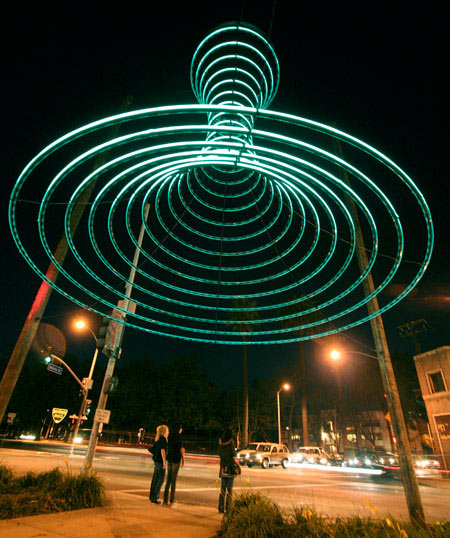
Another aspect of both Stonehouse and Union Street that I find interesting is the lack of knowledge about the boundaries of the area.  Many people who travel down Union Street are unlikely to acknowledge the fact that they are travelling right through the heart of the Stonehouse region.  The joining of Stonehouse, Derriford and Plymouth into a single city i.e Plymouth, meant that the boundaries between the areas have become much more blurred.  Therefore those who travel down or up Union Street are more likely to understand the area to be Plymouth than Stonehouse, apart from perhaps those who live locally and have built up a history of the area via this.  Stonehouse being such an important area historically, and still an interesting and dyanamic location to this day should probably have more acknowledgement as a location than it is currently recieving.  This interests me in terms of improvements to the area, as it would be good to bring a stronger identity back to the area.  Below is a picture of a sculpture in California that acts as a signifier of the boundary between Beverly Hills and West Hollywood:


This sculpture, as well as being used to identify the boundary is also engaging as it draws the viewers eye upwards as you walk below it, and in doing so, allows for an optical illusion to occur in which the colour of the sky is altered at certain times of day.  Labelled the Empyrean Passage, Dan Corson the creator said:

"Empyrean Passage is reminiscent of both a theoretical black hole and portal into the celestial worlds ... The form is constructed like a giant hoop skirt and gracefully moves in the wind, creating a gossamer lighting effect overhead. While this project is an oculus to the heavens, more focus is usually paid to more terrestrial stars in this neighbourhood. "

The sculpture looks and acts almost like a pillar between the two locations and creates an "entrance gateway" that pedestrians are able to travel underneath, almost transporting them between the two worlds.

This sculpture is interesting as it is interactive as well as symbolic, and also very environmentally friendly.  Although most interesting at night, the Empyrean Passage also is functional in the day due to the added illusive effect on the inner edges of the rings.  This therefore allows for a very functional, engaging and effective addition to the environment whilst giving an invisible, yet important boundary, a physical representation.

Thursday, 22 October 2009

Stonehouse - Union Street Photos

As a group we decided that our focus area will be around Union Street, the main road that cuts through the middle of the Stonehouse region.  We therefore went to Union Street and took photos of the area to better document what the location is like. Below is a straight forward collage of the photos I took in the order that they were taken from top left (first photo) to bottom right (last photo). To see a larger version of this image just click on it:

The aim of the photos was to document not only the area in general but also the areas which could be used as the improvement location as well as elements that characterised the area, such as graffiti and the Dance Academy building.  By putting these images in a temporal format like this it shows how the area changes as you travel through over a period time.  It also shows images that link together easily, such as those of the Dance Academy in the middle of the image.  This is to be expected being that one was taken not long after the other, but it did give me an idea to take the photos and collage them together to make an image of the entire road from start to finish, alike to a really long panorama of the area. In this way the focus of the collage would be the focus of the project, and the result may bring a better understanding of the area to the viewer than the one shown above.  The following is this collage:


To see a larger image click on the picture.   This image allows for the enitre length of Union Street to be in one image.  This also shows the difference between the two sides of the road as the near side has many different aspects to it while the far side of the road has very little.  Also the near side of the road is quite variable in the amount of regeneration.  Some sections had relatively new housing and flats while there is also a lot of buildings which are run down and dilapidated.  This demonstrates theres is quite a lot of regenerative conflict still in this area.  It is also interesting that most of the housing, not only on Union Street, but throughout Stonehouse, is on the near side of this image in the North section of Stonehouse.  Union street in some ways seems to cut the area in two, between residential and more commercial areas. 

IDAT 211 - Visual Perception

Visual perception outlines the ways in which we use visual cues to create meaning in the world.  These include paralax, focus, binocular, and monocular cues.  However our perception can easily be tricked, by subverting the normal rules assoctiated with how we percieve our world.  It is this, the amount of different ways in which we have challenged our visual perception that intrigues me most.  Usually refered to as optical illusions, these exceptions to the rules of perception occur both intentionally and unintentionally, either by means of creation for entertainment, or by conicidence.  For example many people use their artistic talents and also computing to create a wide range of optical illusions, which can require the viewer to either be active or passive in changing their perception.  This is intentional subversion.  However things such as the Charlie Chaplin mask experiment mentioned in the previous post, although set up for the video, may still occur with a mask in every day life.  This is therefore (mainly) an unintentional subversion.  Intentional subversion of our perception is much more common, due to the continuous creation of illusions for entertainment.  Below are a few examples of different types of illusion, both passive and active:

 Julian Beever street art shown from the correct and incorrect viewpoints (passive perception as long as you are in the right place)(http://blog.brains4all.com/brainblog/archives/globe.jpg)

(http://snapshotsofgod.com/images/magiceye.gif)A magic eye picture in which the viewer has to physically change the angle of their eyes to a parallel position in order to view the image (active).  This is both related to perception and to the way in which we physically see. Click on the image for a larger version, can you see the heart?
Traditional optical illusion the composition of the image causes your eyes to see black dots where the white gaps are (passive)


Young woman - old man optical illusion.  This requires the viewer to actually turn the image upside down to see the illusion occur (active) (http://www.yugzone.ru/optical_illusions/img/catPics_perevert.gif)
This therefore demonstrates the wide range of different illusions that exist and how they can be passive or active depending on their content.  All of these images work in some way due to the ways in which our perception functions along a set of rules which we have learnt from birth.  By knowing these rules and developing things that go against them we are able to test our own perception and find out more about the way we find meaning in objects.

Wednesday, 21 October 2009

Stonehouse - The map reformed

As well as having the annotated map in its orginal state, with its original meaning, it can also be rekeyed and edited to create a completely different approach to the content.  The following is my interpretation of the map beyond its original meaning:
The orange circles could represent areas that need improvement in cleanliness.  The larger circles could resemble places where there is a lot of rubbish, while smaller circles resemble less.  In terms of the purple lines, these annotations could resemble movement. The closer the lines are together the more movement there is, the darker lines resembling motored movement, while the lighter purple resembles organic movement.  For the green lines I would suggest that the darker more solid lines represent some kind of wind flow such as areas that are more windy.  Finally the black lines could resemble, pollution rather than traffic flow, as this is a byproduct of the traffic on the roads.
The images below are of the map after being redrawn to represent the information more directly.  This has also been influenced by some of the other interpretations I made above. The first image shows the notations with the original base map of the area, while the second is without this to remove the traditional reference points, and demonstrate the patterns and properties of the annotations. To see larger versions of these images click on them:


In terms of the key for this map the elements work as follows:
The green lines have stayed the same as the viewpoints and organic areas around the Stonehouse region as described in previous posts.  The purple swirls resemble the natural light,  and were drawn like this to resemble that light has a wave length and can be mapped in waves.  The dots of purple resemble the street lighting as these will create round circles of light at night and so it seemed fitting to resemble the artifical light spots using circles. The orange scribbles resemble green areas.  These were mapped as spiky areas as this resembles the look of grass which is linked to the concept of green areas.  Finally the black swirls are a new way of representing the traffic areas.  This annotation was made to also connotate the pollution aspects due to traffic congested areas.
This therefore demonstrates the careful consideration of how the map should be redesigned to better connotate the elements it represents, as well as improving the general look of the image. 

Friday, 16 October 2009

Stonehouse - Group Map

Below is the group map produced to map out different elements of the Stonehouse area.  The frist map shows the original Stonehouse road map, while the second shows the annotations without this input.  By removing the stereotypical map image it enables the annotations to become a map in themselves demonstrating a completely new representation of the area.


This map represents the following things:


The orange circles are green spaces, the light purple lines are natural light and the darker purple lines are street lights, the black lines represent traffic flow, and the green lines represent long distance views and organic areas.
Although each annotation has its own individual meaning, the map as a whole can be studied and interpreted also.  There are a number of things to note about this mapping of Stonehouse.  Firstly there are a number of locations which have fallen as the focus of the annotations.  These areas are around Victoria Park, the coastal areas around the Royal Williams Yard, and Union Street. It is interesting that these areas specifically stand out as this suggests that there is a hidden potential in these areas that has not yet been uncovered.  Union street is particularly interesting in this way, as rather than being a empty green space alike to the other two, it is actually the most commercial and populated section of Stonehouse.  This is because the area acts as a highway through Stonehouse into the centre of Plymouth, and so is constantly used by drivers and pedestrians alike.  Although it is no surprise that Union Street been highlighted in this way, it is interesting that it comes up against two spaces that are very different to itself.
Another interesting aspect of this map is that the areas that are the focus of the mapping are also areas of historical interest. Union Street has always been a major road in the area, and used to be the centre of nightlife both for military and civilian locals, as well as an area that has a history of problems with drugs and violence.  The area around the Royal Williams Yard has gone through a number of different transformations. This includes the major Navy usage in previous years including during the World Wars, and the regeneration in current years into apartment and business space.  Finally the Victoria Park area has an interesting history as its topography has been changed over time due to human intervention.  It was originally a lake like area linked to Stonehouse Creek which ran between the Stonehouse and Devonport regions.  When the lake, known as Deadlake, became stagnant and a health risk in 1887 action was begun to fill in the area, and this was completed in 1898. (http://www.plymouthdata.info/Parks,%20Victoria.htm). This is particularly interesting as a changing topographical history in such a small period of time is quite a unique aspect.
Overall therefore this map allows for some interesting discoveries about the Stonehouse region that looks beyond the normal interpretations to the more hidden aspects of the environment.